Exploring Biodiversity: A Web GIS Journey Through Mount Olympus
Introduction:
Nestled among the rugged landscapes of Greece, Mount Olympus stands tall, not only as the country’s highest peak but as a sanctuary of natural beauty and biodiversity. This majestic mountain is not just a trekker’s paradise; it’s a living laboratory of life, from its peaks to its valleys. To better understand and appreciate the biodiversity of this unique region, the Olympus National Park Management Unit has partnered with us to develop a custom web GIS application.
Unlocking the Secrets of Olympus:
Our collaboration with the Olympus National Park Management Unit has led to the creation of a powerful and user-friendly web GIS application. This tool is designed to provide visitors, scientists, and nature enthusiasts with a deep dive into the heart of Mount Olympus.
Key Features of the Web GIS:
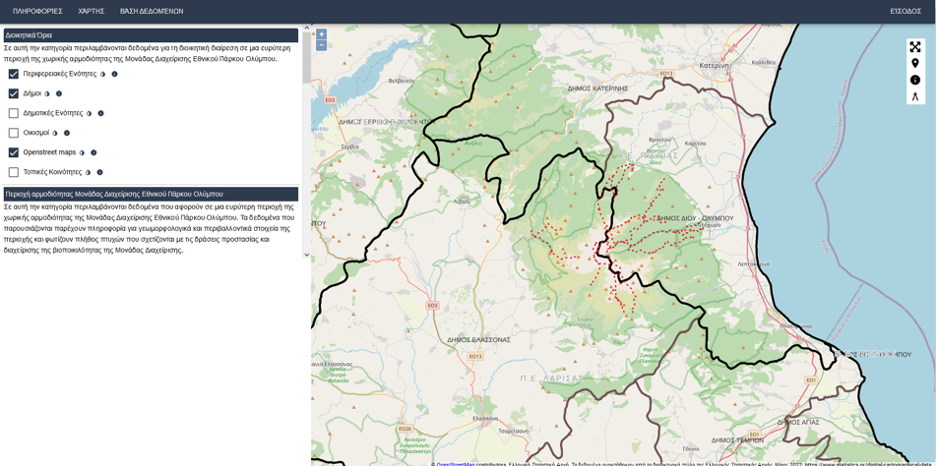
1. Geospatial Data Management: We utilized open-source GIS technology to manage the vast geospatial data related to Mount Olympus. This ensures that we have an accurate representation of the mountain’s unique terrain, ecosystems, and geological features.
2. Custom Application: Our web GIS application has been custom-built to cater to the specific needs of the Olympus National Park. It is intuitive, user-friendly, and accessible on various devices, making it the perfect companion for all park visitors.
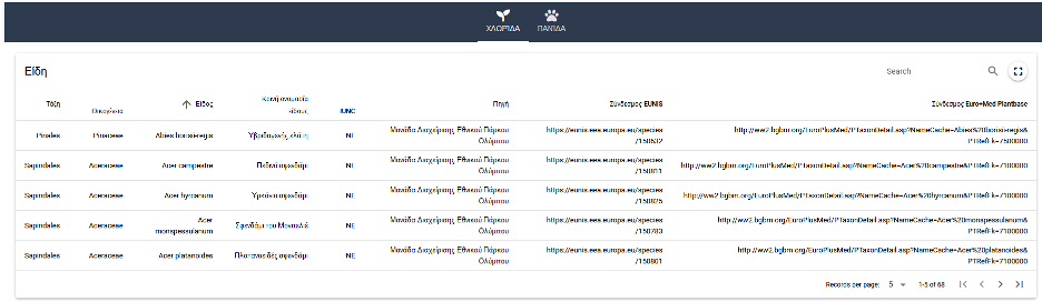
3. Biodiversity Database: One of the most remarkable aspects of our web GIS is the comprehensive database it offers, housing information about the fauna and flora that call Mount Olympus their home. Users can explore this treasure trove of knowledge to gain insights into the rich tapestry of life here.
4. Climate Insights: Climate plays a crucial role in shaping the ecosystems on Mount Olympus. Our application provides users with real-time and historical climate data, helping them understand the mountain’s dynamic weather patterns and their impact on the region’s biodiversity.
Journeying Through Mount Olympus:
- Species Exploration: With just a few clicks, users can embark on a virtual expedition to discover the diverse range of species living on Mount Olympus. From the elusive chamois to the enchanting orchids, the web GIS showcases the park’s biological richness.
- Educational Resources: Whether you’re a student, a researcher, or simply curious, the application offers a wealth of educational materials. Learn about the unique adaptations of mountain-dwelling species, the cultural significance of the area, and ongoing conservation efforts.
- Planning and Navigation: Visitors to the park can use the web GIS for trip planning, checking trail conditions, and ensuring they respect the park’s boundaries. Stay on marked paths and make the most of your adventure.
Preserving and Sharing the Wonders of Mount Olympus:
The web GIS application is not just a tool for exploration; it’s a commitment to the preservation of Mount Olympus and the biodiversity it shelters. By sharing knowledge and fostering a deep appreciation for this natural wonder, we hope to inspire a community of responsible stewards for generations to come.
Conclusion:
Mount Olympus is a realm of unparalleled beauty and ecological significance, and our custom web GIS application is your passport to its hidden treasures. We invite you to explore, discover, and learn about the biodiversity of this remarkable mountain, all while contributing to its ongoing conservation. Visit our web GIS, embark on your digital journey, and let the wonders of Mount Olympus capture your heart and imagination.

Leave a Reply